Au Sable Point Lighthouse "A Quick Look Back In time"
 Mariners for many years dreaded the eighty miles of Lake Superior's dark coastline known as "Au Sable Point." This dark and dangerous coastal area was unmarked by any type of navigational aids or lights. Since the early 1800's this stretch of unsettled, sheer rocky cliffs, dense unbroken forests, and dangerous reefs were referred to by mariners as the "Shipwreck Coast." This area claimed dozens of vessels and countless lives.
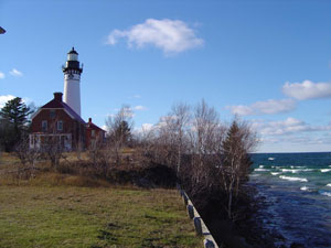
The United States Lighthouse Board decided they needed to fill this long dark traitorous stretch of coastline with a light. The coastline stretched east from Grand Island Lighthouse to the beacon at Whitefish Point Lighthouse. Finally in 1874 a lighthouse was placed on Au Sable Point. The cost to build this light-station was a staggering $40,000 and the United States Treasury stepped up and funded this undertaking. The United States Lighthouse service built an eighty-seven foot red brick tower and a few other brick structures on a bluff that stood about one hundred and fifty feet above Lake Superior's waterline.
The Lighthouse Service ordered a new 180 degree, 3rd Order Fresnel lens from L. Sautter & Company, located in Paris, France. Sautter & Company would construct the new lens, crate it up, and put it on a vessel bound for the US. The lens would eventually make its way from Lighthouse Depot located in Detroit, Michigan to Au Sable Lighthouse. Once it arrived on site, the new Fresnel lens was carefully assembled by a crew who was working on site and then hoisted to the top of the iron lantern room where it was carefully moved inside the iron lantern room. The newly lit beacon displayed a bright fixed white light that was visible some seventeen miles out into Lake Superior. There is a large two-story red brick keeper's dwelling that extends off the conical tower. The crew of workers also constructed a large red brick fog signal building, a boathouse, a couple of oil houses and a privy on site.
This location was considered by those who served at Au Sable as one of the most remote lighthouse locations in the "State of Michigan." Keepers from Au Sable had two choices when it came to picking up supplies, mail, dry goods, fuel oil, etc. They could hike the twenty miles from the light to Grand Marais or go by rowboat. In 1939 to United States Lighthouse Service was absorbed by the newly formed United States Coast Guard. Life around the light really didn't change much. It took a number of years before the Coast Guard took full control of this remote station. In 1958 the United States Coast Guard automated Au Sable Point Lighthouse. As time went on, the property and structures were turned over to the National Park Service and became part of the Pictured Rocks National Lakeshore.
In 1972 the United States Coast Guard removed the 3rd Order Fresnel lens from service. They replaced it with a 300 Millimeter Tideland Acrylic Signal Lens. The new signal lens was mounted to the exterior of the iron railing system that surrounds the iron lantern room. The National Park Service asked the Coast Guard to leave the original 3rd Order Fresnel lens in the lantern room.
The signal is illuminated today by a solar photo-voltaic generation grid that is activated by an internal control panel. The two main buildings are now powered by a liquid propane gas system and the site has been restored to its original glory.
Au Sable Lighthouse is open to public from "Memorial Day to Labor Day" and there are guided tours available. I highly recommend you make it a point to come by and check out this great old lighthouse. "I've personally experienced this wondrous place during all four seasons and I have to say each one of them was exciting."3.jpg)
Additional Information:
"Au Sable Point Lighthouse or as some call it Au Sable Light-Station stands 1 1/2 miles northeast of the Lower Hurricane River Campground within Pictured Rocks National Lakeshore. The campgrounds are twelve miles west of Grand Marais, Michigan, on Alger County Road H-58. Visitors are asked to park in an area adjacent to the campground entrance. From the parking area you will hike along the trail "North Country Trail" that runs along Lake Superior’s rugged coastline for about a mile. As you hike towards the lighthouse take in the beautiful views of the lake. There is a fee for guided tours of the lighthouse."
About the Author:
Scott W. Bundschuh wrote his first book called: Crisp Point Lifesaving Station & Lighthouse “Lifetime of Historical Service that was published by Sheridan Books in June, 2009. Over the past few years he has written articles for The Keepers Log, Wreck & Rescue Journal, Inland Seas and Lighthouse Digest. In 2010 he was awarded “Man of the Year” for outstanding pursuits, achievements, dedication and excellence as recognized by American Biographical Institute. In 2011 he was awarded the “Order of International Ambassadors” medal by the American Biographical Institute. He is an elite member of this order that represents international achievement and success. His next two books are called: Saginaw River Range Lights “A Hopeful Future, After A Lifetime of Service” & Galloo Island Lighthouse, Lifesaving Station & Lifeboat “Stories From The Past & Present” There from 1936 to 1973”, should be ready for publication by the end of December 2012. Scott is a Great Lake Lighthouse Historian, Lighthouse photographer and he writes his own Google Blog called: Great Lakes Lighthouse Historian. When he’s not writing, he spends some of his spare time building and restoring furniture and building HO Train Dioramas.
